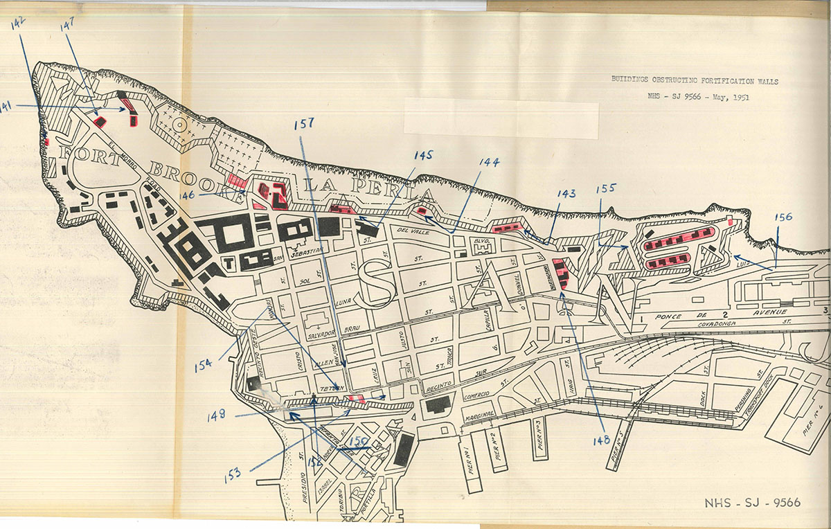
Mapa y fotos de varios edificios obstruyendo las fortificaciones del Viejo San Juan en 1951. Forma parte de un reporte preparado por el superintendente del San Juan National Historic Site, David J. Jones sobre varios edificios localizados en las murallas históricas de la isleta. El reporte incluye las sugerencias del superintendente para la remoción de algunos de estos edificios. Además incluye 3 cartas cursadas entre el superintendente y el general Robert M. Bathurst, comandante del U. S. Army Forces Antilles en Fort Brooke, y 14 fotos que ilustran los edificios que obstruyen las murallas. Las cartas evidencian las acciones tomadas por el superintendente del San Juan National Historic Site para proteger y conservar las fortificaciones históricas del Viejo San Juan.
La mayoría de los edificios mencionados en este reporte fueron construidos por el Ejército de los Estados Unidos durante la época que Fort Brooke estuvo operando en el Viejo San Juan; algunos datan de la época española previo a 1898. Todos los edificios del ejército estadounidense en este reporte fueron removidos eventualmente, como la piscina y el club de oficiales en terrenos de El Morro, cerca de la casa del guardia del bastión San Antonio; y la casa del sargento y el estacionamiento sobre el bastión de las Palmas frente a la intersección de la calle de San José y la calle de Tetuán.
A continuación podrá ver las fotos de las obstrucciones a las fortificaciones listadas en el mapa. Incluimos bajo cada foto el texto descriptivo usado en el reporte:*
* Nota: no hay una correspondencia exacta entre la localización de las fotos indicadas en el mapa y las fotos que aparecen en el reporte. Por ejemplo, la foto 142 se indica en el mapa pero no se incluye, además la localización de las fotos 149 y 151 no se indican en el mapa.

Photo No. 141 – Swimming Pool and Bath House of Fort Brooke.
This is an intrusion in the San Antonio Bastion and built adjacent to the powder house which served that Bastion.

Photo No. 143 – View showing Army quarters on San Sebastian Bastion along del Valle Boulevard adjacent to Fort of’ San Cristobal.
Hidden within the trees are three sets of quarters which should never have been constructed at this location.

Photo No . 144 – Quarters on San Tomas Bastion along Del Valle Boulevard.
This set of quarters likewise preempts the Bastion overlooking the sea side.

Photo No. 145 – Coast Guard Radio Station at Las Animas Bastion on Del Valle Boulevard.
This consists o: the two structures shown within the cyclone fence and the residence just beyond.

Photo No. 146 – View of Service Club, Post Exchange, Nurse’s Quarters, and Outdoor Theatre at the entrance to Fort Brooke.
These structures completely hide the wall, a portion of which can be seen at the extreme left.

Photo No. 147 – Officer’s Club, Fort Brooke, as seen from the land side of El Morro.
This is located opposite main entrance to El Morro, and as such is a distracting factor.

Photo No . 148 – The Army quarters located along the slope of the glacis to the west of San Cristobal.
This housing probably dates prior to 1898. The view of San Cristobal from this point would be enhanced considerably by the removal of these buildings.

Photo No. 149 – Power line poles built on the wall near the Chamber of Commerce Building.
Parked cars likewise obstruct the view of the fortification walls near the Post Office.

Photos 150 – 151 – 152. View showing the south wall of fortification above what is known as Paseo de la Princesa.
Most of these structures are of an early date.

Photo No. 153 – Additional view of south wall of fortifications to right of previous photos.
The Sergeants house is alongside the palm tree to the left of the “Hotel Palace” sign.

Photo No. 154 – Side view of the Sergeants’ House showing Army parking lot in foreground.
This frame structure entirely out of keeping with the architecture of the locality. Sentry box to rear of house not visible from this angle.

Photo No. 155 – La Princesa Housing Area (Army) as seen from San Cristobal.
Within the heavily wooded area shown , there are ten sets of quarters and several small buildings which completely dominate the out works of San Cristobal. This set of fortifications dramatically illustrate the concept of defense in depth, but are inaccessible to the public. This is a view of this area as would normally be seen by visitors to the Fort of San Cristobal.

Photo No. 156 – Another view of La Princesa housing area with Abanico (the fan fort) shown at the left.
San Cristobal would be visible if it were not for this housing development.

Photo No. 157 – Sergeants’ House – Quarters No. T-301.
View showing manner in which this structure obstructs the fortification wall at the junction of San Jose and Tetuan Streets.
A continuación incluimos las cartas cursadas entre el superintendente del San Juan National Historic Site, David J. Jones y el general Robert M. Bathurst, comandante del U. S. Army Forces Antilles en Fort Brooke. Bajo cada carta reproducimos el texto para facilitar su lectura.

San Juan National Historic Site
San Juan, Puerto RicoMay 8, 1951
Brig. Gen. Robert M. Bathurst, USA
Commanding General
U. S. Army Forces Antilles
Fort Brooke
San Juan, Puerto RicoDear General Bathurst:
You will recall the small frame house (T-301) situated on the bastion that is being used as the Army parking lot near the El Mundo Building in San Juan.
What is the possibility of having it removed? It is entirely out of keeping with the architecture of that section; it obstructs the fortification walls and what is rather a nice view of the bay.
As you know, the National Park Service is interested in gradually removing the non-historic buildings along the city walls. This particular proposal was initiated by Mrs. Munoz Marin through Resident Commisioner Fernos Isern.
I would appreciate your reaction to this matter. Perhaps through the active support of all interested parties something could be achieved.
Sincerely yours,
/Sgd/ David J. Jones
David J. Jones
SuperintendentTRUE COPY

HEADQUARTERS
UNITED STATES ARMY FORCES ANTILLES
OFFICE OF THE COMMANDING GENERAL
FORT BROOKE, PUERTO RICO9 May 1951
Mr. David J. Jones
U. S. Department of the Interior
National Park Service
San Juan National Historic Site
San Juan, Puerto RicoDear Mr. Jones:
This will acknowledge your letter of May 8 in which you inquire concerning the possibility of removing the small frame house (T-301) situated on the bastion that is being used as the Army parking lot near the El Mundo building in San Juan.
With the present critical shortage of quarters available to this command, I can not at this time consider removing a building which served a necessary purpose, and for which there is no replacement. While it is true that the building in question does obstruct the view of the bay and of the fortification walls, as stated in your letter, it is also true that many other buildings are located to obstruct the same view.
I will bear in mind your thought and when and if the situation permits consideration of such action, will attempt to give every possible consideration to your request.
Sincerely yours,
/Sgd/ Robert M. Bathurst
ROBERT M. BATHURST
Brigadier General, USATRUE COPY


File Ref: H3015 SANU
United States
Department of the Interior
National Park Service
San Juan National Historic Site
San Juan, Puerto RicoMay 11, 1951
Memorandum
To: Regional Director, Region One
From: Superintendent, San Juan NHS
Subject: Buildings Situated on the Historic Walls of
San Juan, Puerto RicoYou requested on March 5 a report on the buildings obstructing the fortification walls of San Juan, particularly that one known locally as the Sergeant’s House. Attached is a series of photographs with a brief description of each and a map showing the location of said buildings and the angles from which the photo were taken.
No buildings have been constructed since the Cooperative Agreement was signed. In fact, some of those photographed were built before the walls, particularly in the area of El Paseo de la Princesa. The elimination of all structures which infringe upon the fortification walls, is virtually impossible and not desirable.
On various occasions the question of gradual elimination of Army buildings, has been discussed in general terms with Army officials, including the various Post Commanders, and Commanding Generals. There is considerable variation in opinion, but it is generally conceded that the outlying structure of Fort Brooke could perhaps be demolished eventually.
The lack of funds is the principal reason why the Army can not consider the elimination of any of these buildings at the present time. General Bathurst is, however, attempting to obtain an appropriation under the Therry Act to construct new ones. It is possible that some agreement could be reached with the Department of the Army to eliminate certain housing in return for support of their needs.
I would recommend that we concentrate our efforts upon the removal of the Sergeant’s house, and the quarters along Del Valle Boulevard, shown in photos Nos. 143 and 144. There has been a plan considered from time to time to turn Del Valle Boulevard into a scenic drive. The Army is sufficiently aware of this proposal and the feasibility of it being achieved, to have not made any real improvements in these quarters. Now, of course, any possibility of a scenic drive is delayed by the world situation. Any housing outside of Fort Brooke proper and La Princesa near San Cristobal is good target for clearance. The Army considers outlying structures difficult to administer.
It is interesting to find that the Spanish prohibited buildings within 300 paces of the walls. This was strictly enforced until 1800. As late as the 1850’s they ordered the demolishing of all unauthorized buildings in the zone.
(SIGNED)
David J, Jones
SuperintendentIn quadruplicate
Attachments
Puede ver y descargar copia del mapa, las cartas y las fotos de este reporte en el portal del National Archives Catalog.
Fuente: National Archives Catalog


You must be logged in to post a comment.