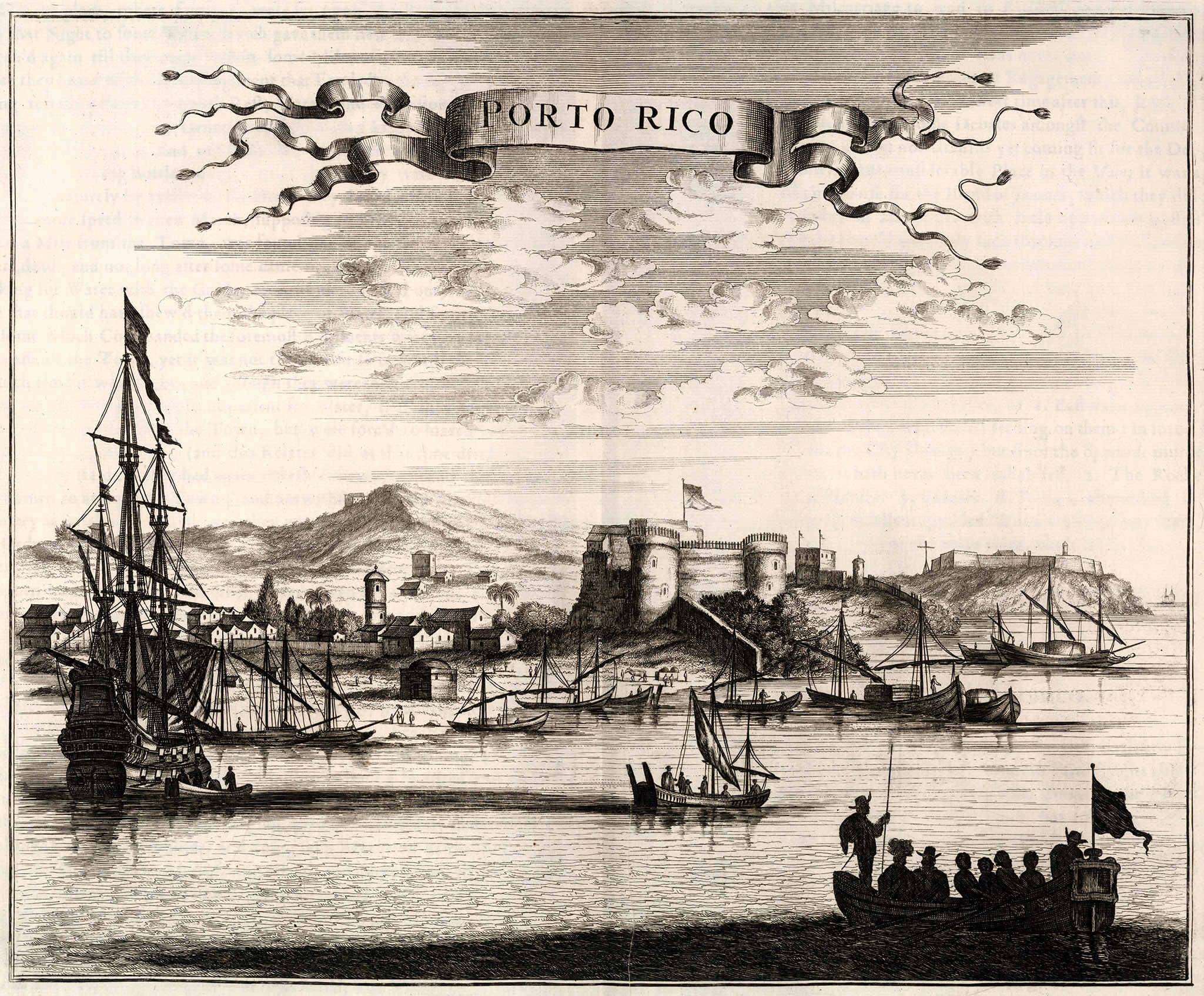
Ilustración que muestra una vista de la entrada a la bahía de la ciudad de “Porto Rico”, publicada en 1671 en el libro “America”* del cartógrafo escocés John Ogilby (1600-1676). En la misma vemos la entrada a la bahía de San Juan y las fortificaciones que la protegían de ataques enemigos. En el primer plano vemos varias embarcaciones de la época.
Según Ogilby, la ciudad principal de Puerto Rico es St. John de Porto Rico, la cual describe de la siguiente manera: “The chief Towns in this Iſland, are I. Porto Rico it ſelf, commonly call’d St. John de Porto Rico (ſo term’d by Christopher Columbus, as being the ſirſt Land diſcover’d by him in the Year 1493. at that time when he could not perſwade his Seamen, wearied out with continual hardſlhip, from returning, if they diſcover’d not Land in two days) a ſtrong and neat Town, built by the Command of Philip the Second, King of Spain : It was attempted by Sir Francis Drake in the Year 1505; without ſucceſs, but a few years after taken by the Earl of Cumberland.”
Más adelante abunda en su descripción diciendo: “Juan de Porto Rico ſtands Eaſtward at the beginning of the North Coaſt,on a ſmall Peninſula, joyn’d to the Iſland by an high Iſthmus call’d Puente de Aguilar. Near the Mouth of the Haven lies on a riſing Hill the Fort Morro Empinado, built triangular by John de Texila and Baptiſta Antonelli (who alſo planted there forty Guns}, and ſurrounded with the Sea, which renders it a well fortifi’d place. The Governor Diego Mendez de Valdez had in it fifteen hundred Men and eighty Horſes, when the forementioned valiant Duke of Cumberland with a far leſs number fell upon him in the Year 1597. and not onely took the City Porto Rico, but ſeveral other Fortifications; and beſides an invaluable mafs of Treafure he carried away eighty Guns.”
Puede ver y descargar copia de esta ilustración del libro de Ogilby en la página web del David Rumsey Historical Map Collection.
Puede ver y descargar copia del libro completo de Ogilby en la página web del Internet Archive.
Además puede ver y descargar una copia a color de esta ilustración en la página web de Barry Lawrence Ruderman Antique Maps, Inc..

Versión a color de la ilustración “Porto Rico” que aparece en el libro “America” de Ogilby (1671) cortesía de Barry Lawrence Ruderman Antique Maps, Inc.
Nota: Como nos han comentado varios lectores de la página de Facebook de GeoIsla, la imagen está impresa al revés. Imaginamos que pudo haber sido un error del grabador. Desde la bahía de San Juan mirando hacia La Fortaleza (que vemos al centro), el castillo de El Morro (al fondo a la derecha) debería estar a mano izquierda. Incluimos la imagen invertida en sentido horizontal para hacer la comparación.

Ilustración “Porto Rico” del libro “America” de Ogilby (1671) invertida en sentido horizontal. Desde la bahía de San Juan mirando hacia La Fortaleza (que vemos al centro), el castillo de El Morro (al fondo a la derecha en el original) debería verse a mano izquierda. Al parecer el grabador cometió un error e imprimió la imagen al revés.
Fuentes: David Rumsey Historical Map Collection, el Internet Archive y Barry Lawrence Ruderman Antique Maps, Inc.
*El nombre completo del libro “America” de Ogilby es “America: Being The Latest, And Most accurate Description Of The New World; Containing The Original of the Inhabitants, and the Remarkable Voyages thither. The Conquest of the Vast Empires of Mexico and Peru, And Other Large Provinces and Territories … Collected from the most Authentick Authors, Augmented with later Observations, and Adorn’d with Maps and Sculptures, by John Ogilby, esq; His Majesty’s Cosmographer, Geographick Printer, and Master of the Revels in the Kingdom of Ireland. London, Printed by the Author, and are to be had at his House in White Fryers, M.DC.LXXI.”


You must be logged in to post a comment.